#CAwx #MTR #graphicast
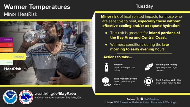
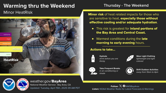
Minor risk of heat related impacts for those who are sensitive to heat, especially those without effective cooling and/or adequate hydration.
This risk is greatest for inland portions of the Bay Area and Central Coast.
Warmest conditions during the late morning to early evening hours.
Recent searches
Search options
#graphicast
#CAwx #MTR #graphicast
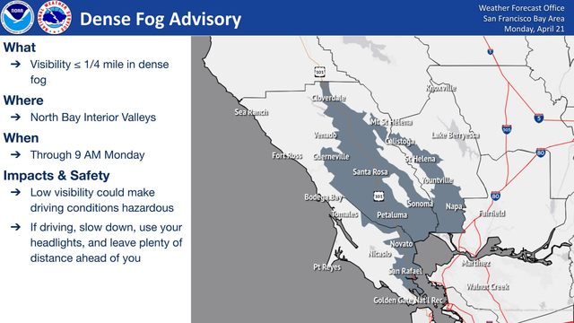
Dense Fog Advisory is now in effect through 9 AM for the North Bay Interior Valleys. Visibilities will be less than one quarter mile at times. Low visibility could make driving conditions and navigating hazardous.
#CAwx #MTR #graphicast
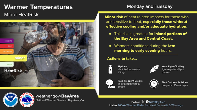
Minor risk of heat related impacts for those who are sensitive to heat, especially those without effective cooling and/or adequate hydration.
This risk is greatest for inland portions of the Bay Area and Central Coast.
Warmest conditions during the late morning to early evening hours.
#CAwx #SGX #graphicast
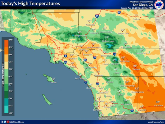
Forecast high temperatures today Saturday Apr 19, 2025. For the coastal areas: 65 to 72, western valleys and inland Orange County: 71 to 76, inland valleys: 68 to 77, mountains between 4000 ft and 7000 ft: 55 to 64, high desert: 69 to 73, low desert: 80 to 85.
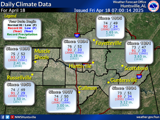
#ALwx #graphicast #HUN This graphic contains daily climate data (climate normals and records) for today for the sites listed. The legend is in the upper left portion of the image. The current normals period is 1991-2020.
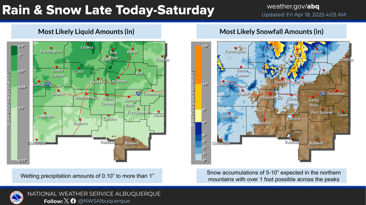
#NMwx #graphicast A storm system will cross the state late Friday through Saturday, bringing much needed precipitation. While rain is expected for most valley locations, significant late season snowfall is likely in the mountains. The peaks of the northern mountains could see snow amounts exceed one foot!
#NMwx #graphicast Strong winds tomorrow will create areas of blowing dust, leading to reduced visibilities and hazardous driving conditions. Know what to do if you get caught in a dust storm!
#CAwx #SGX #graphicast
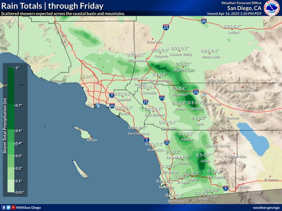
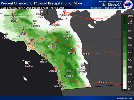
Two waves of light precipitations are expected in the next few days. The first wave will bring scattered showers tonight through Thursday morning across the coastal basin but focused mainly in San Diego County. The second wave will bring scattered showers and high elevation mountain snow Thursday evening through early Friday, with isolated afternoon showers possible inland. Totals are generally expected to remain b
#CAwx #SGX #graphicast
Two quick systems will sweep through Southern California late week. The first system could bring some light intermittent rain across the coastal basin Thursday morning. The second system could bring some additional periods of light rain and high elevation mountain snow late Thursday through early Friday, with isolated afternoon showers possible inland. There still remains uncertainty on the totals from the systems
#CAwx #MTR #graphicast
Minor risk of heat related impacts for those who are sensitive to heat, especially those without effective cooling and/or adequate hydration.
This risk is greatest for inland portions of the Bay Area and Central Coast.
Warmest conditions during the late morning to early evening hours.
#CAwx #MTR #graphicast
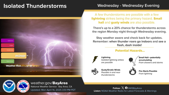
There’s up to a 20% chance for thunderstorms across the region Wednesday. Isolated lightning strikes are the primary hazard. Small hail and gusty winds are also possible. Stay weather aware and check back for updates. Remember: when thunder roars go indoors and see a flash, dash inside!
#CAwx #MTR #graphicast
There’s up to a 20% chance for thunderstorms across the region Monday night through Wednesday. Isolated lightning strikes are the primary hazard. Small hail and gusty winds are also possible. Stay weather aware and check back for updates. Remember: when thunder roars go indoors and see a flash, dash inside!
#CAwx #MTR #graphicast
There’s a 15-20% chance for thunderstorms across the region Wednesday and Wednesday Evening. Isolated lightning strikes are the primary hazard. Small hail and gusty winds are also possible. Stay weather aware and check back for updates. Remember: when thunder roars go indoors!
#CAwx #LOX #graphicast
A slow moving low pressure system will wobble around the region this week.
#CAwx #MTR #graphicast
Dense Fog Advisory is now in effect through 10 AM for Monterey Bay Coast and San Francisco Peninsula Coast, including Monterey Bay. Visibilities will be less than one half mile at times. Low visibility could make driving conditions and navigating hazardous.
#CAwx #SGX #graphicast
Confidence is slowly increasing in some precipitation, especially for the mountains, for late this week. Timing/location/amounts remain uncertain at this point, as well as snow levels which will determine snowfall totals (if any) for the higher terrain.
#TNwx #graphicast #MEG River flooding is expected to continue across the Mid-South, with major flooding ongoing across portions of the Mississippi River. For the latest river forecast information, visit water.noaa.gov.
#CAwx #MTR #graphicast
We continue our stretch of above normal warmth as evidenced by a couple of record high temperatures that were tied, with one new record high set. Note the period of record for these sites runs back through 1998 and as a result, they are not necessarily "official" climate sites just yet. Additional warm conditions are anticipated this week with "minor" HeatRisk continuing.
#NMwx #graphicast The shading in this chart shows the range of forecast temperatures for the Albuquerque International Sunport Thursday through Sunday. The solid line represents the most likely temperature. There is a likely (>95%) chance of highs greater than 80F tomorrow and Friday Friday. On Saturday, there is approximately a 35% chance of reaching 90F at the Sunport! Locations in the valley would have a higher chance of reaching 90.

